Mendon Town Forest A Google earth satellite map of the Town Forest, which is the bulk of the heavily forested area, and adjacent properties. It is located in the South-western corner of Mendon near the Millville & Uxbridge town lines. A neighboring property and popular tourist attraction is Southwick’s Zoo. The fire tower, indicated on the map, is the highest point on Wigwam Hill. The large rock carved by J. F. Taft in 1876 is a short distance from the tower (more about these below). The earliest inhabitants of what is now the Town Forest were the Native American Nipmucs. This virgin people of the soil, as they were called by Albert E. Jones, were scattered and fast disappearing when the first Europeans came to our shores. Looking westward from what is now Wigwam Hill, the landscape was unspoiled and undeveloped. No church spire then could be seen pointing the way to heaven. Nearly a hundred years were to elapse before the first tall chimney would mark the beginnings of industry in the Blackstone Valley, industry that would spur the growth and development of the surrounding communities. The hill is thought to have gotten its name from being the place where the Nipmuc Indians (a/k/a Native American) lived in wigwams. The name “Wigwam” for this hill has caused some confusion as to the origin of its name. According to Annals of Mendon from 1659-1880 by Dr. John Metcalf; “Caleb's hill was so called because Caleb, the Indian to whom the town paid bounties for killing wolves, had his wigwam there.”(1) Caleb’s Hill was not what is now called Wigwam Hill, but rather Inman Hill. Woodland Thompson was the first white settler and proprietor on Wigwam Hill. Wigwam Hill & Tower Road After the Industrial Revolution became established in the valley, one could see to the west, the villages of Whitinsville, North Uxbridge, Uxbridge Center, the Woolen Mills, the long line of the Uxbridge Hills and the 3 rivers that wind through those towns from the top of Wigwam Hill. A score of neat farm houses which dot the countryside and the blue peaks of Wachusett and Monadnock mountains could also be seen in the distance. Today (1905) very few people go here but, time was when the place was frequently visited and it is well worth a visit from anyone who enjoys looking at long stretches of landscape, immensity of blue sky, and a horizon far removed. The same is true today. In 1726 a 3-rod way (1 rod= 5 ½ yards or 16 ½ feet or 3 rods = 49 ½ feet) was laid out from the Arnold Taft place over Wigwam Hill through Chestnut Hill to John Darling’s at Millville. This being through wild common lands, there being but one house on the entire site, that of Cornel B. Benson. |


Darling appear below the boundary line between the North and South Parish. The South Parish became the town of Blackstone in 1845 and the town of Millville in 1916. On May 28, 1870 the Town voted to accept of a road laid out on Wigwam Hill northerly from the house of Nathaniel Taft and running easterly to intersect with the road from Mendon to Millville (then part of the town of Blackstone) and to discontinue that part of the road over Wigwam Hill lying northerly of the point of beginning of the above new road. On the 1831map, this appears to be the section which runs north from Wigwam Hill to the Arnold A. & Stephen Taft residence(s). |

The Observatory, Dance Hall, and Grist Mill Thompson Taft, who represented the 4th generation of Tafts who owned Wigwam Hill, recognized the great view of the valley an observation tower could provide. He decided, in 1849, to built one on the summit of that hill. The Observatory (sometimes called the Monument) was 55 ft. high, 12 feet square at the top, and 24 square at the base.”(2) Another account from the states; “it was 84 ft. tall, 10 feet square at the top, and 20 feet square at the base, although they admit their measurements may not be exact with proper arrangement inside to get to the top (stairway).”(3) Caleb S. Taft, a blacksmith from Blackstone (now Millville) testified; “The framing of the building was done by Thompson and Austin Taft. The 4 tall uprights, 2 of chestnut and 2 of white pine, were brought from Burrillville & Smithfield, R.I. The iron to brace it against the wind was Lowmore Iron, the best in the world, and was forged in my smithy by my father Caleb Taft. Thirty-eight men by the name of Taft assisted in raising the structure. The admission price to the observatory was 10 cents. An elderly gentleman (not identified) who was born and lived near the hill his entire life said; “Why, sir, from the top of the observatory…one could easily discern, with the aid of a good glass, on a day when the atmosphere was very clear, the masts of the shipping in Boston harbor.”2 A year or so after the observatory was built, Mr. Taft made an extension to it 40 feet long and 22 feet wide which was used as a dance hall, at the dedication of which a large company of ladies and gentlemen were present. There was feasting and dancing and Prof. Absalom Daniels, famous in his day as a dancing teacher and master of ceremonies, presided on the occasion where he entertained the company in dancing a hornpipe in a most lively and energetic style. Later a grist mill run by horsepower was added. These buildings stood for some years until the dance hall was taken down and made into a mill. Soon after the timbers of the observatory were found to be coming unsound and it was taken down rather than repaired. From the map it appears the observatory and other buildings were built near the Taft Rock (see “Points of Interest” below) as this area is one of the highest points, of Wigwam Hill. The spot upon which the fire tower now stands is the highest point on the hill at 573 feet above sea level, so the observation tower and other buildings probably stood near the present tower. There is what appears to be part of a mill stone across Tower Road from the fire tower and near the beginning of the path which leads to the old mill and dam site. There is also a well for supplying water (see below), which is no longer active. Perhaps this was the site of the dance hall and grist mill. |

frequently visited it and remained for the whole day. Wigwam and Misco hill (located in the northern corner of Mendon) were also occupied as stations for observation in the Trigonometrical Survey of the State made for the construction of a topographical map by Simeon Borden, Esq. Fire Tower and Mill and Dam Sites Frank M. Aldrich, Fire Warden of Mendon, received word in August of 1915 that the State was to begin, at once, the erection of a fire tower on Wigwam Hill in Mendon. The tower would be similar to the one on Fay Mountain in Westboro. The tower was 50 feet high and was opened for the first time in May 1916 when a watchman was installed. It served the State and protected for 38 years, what was to become the Town Forest in 1944. In 1954 a new 70 foot high fire tower was built. The new tower rose 20 feet above the old one which stood nearby which was later torn down. A public dedication of the newly completed fire tower was held on August 20, 1954 at 10:30 am. In charge of the formal dedication was Howard Hurlihy, the State District Fire Warden. |


wind speed to determine if windmill power is a viable option for Mendon. Mendon Acquires the Town Forest The land was taken as tax title property in 1934 by deed Book 2617 Page 258 for failure of the former owner, Charles L. Robinson of Providence, R. I. to pay the taxes due in the amount of $63.29. The Town voted to convert the tax title property to a Town Forest under Mass. General Law, Chapter 143, Section 35, in 1944. The total acreage acquired was approximately 120 acres +/- which includes the area known as Wigwam Hill. Another 2.5 acres was located across Millville Street (on the east side of the street, known as lot 210). Fifty dollars for rent of the land on which the Tower stands was received from the Department of Conservation. There were 1900 red pine and 900 white pine seedlings set out at the Town Forest and planted by volunteers. Many of the trees planted were lumbered in 1987 and recently (2007? -- 20 year cycle?). The well on the property (there were two) was cleaned out, which made drinking water available. This well was located along Tower Road not far from the fire tower and near where the mill stone was found. The Boy Scouts and other groups from Town, helped by water provided by this well, enjoyed outings, picnics and weenie roasts at various times during the season. Over time, as young people grew up and others moved on, the area became less popular and was neglected. The well is no longer sanitary for drinking or washing. |


The Town Forest Committee was working on plans to further the usefulness of the Forest in 1945 and it was hoped that groups from Town would avail themselves of this site. Unfortunately, in most cases these plans or those proposed below in 1988, which were similar, were not carried out. A Management Plan for the Mendon Town Forest by the Mendon Conservation Commission and the Yankee Forest Cooperative Project was prepared on January 23, 1989. The recommendations from this report are presented below. To see the entire report, please go to: |


The map of the Town Forest is part of the Forestry Report. Town Forest Points of Interest Taft or Anchor Rock |

The large rock with carvings by J. F. Taft, who according to Richard Taft Messinger and other members of the Taft Family Association, may have owned the saw mill located in what was to become the Town Forest. The carvings are shown in detail below. |

nation’s 100th birthday was on July 4th of that year. |

The two “3 rings” symbols and “F.L.T.” carved inside the rings in photo #1 on J. F. Taft’s Rock represents the Independent Order of Odd Fellows - also known as "The Three Link Fraternity" which stands for Friendship, Love and Truth. J. F. Taft must have been a member of this organization. “G. B.” is an unknown. |

and name “A I ALEXANDER” is unknown to us at this time. There were residents of the town by the name of Alexander. A possible explanation for the anchor symbol is the following: |

Anchor Cross ANCHOR CROSS: Hope - This cross goes back to the days of persecution before Constantine. To non-Christians the symbol appeared to be an anchor, but to Christians it was a symbol of hope. But where did Christians get the idea to use an anchor in the first place? The anchor appeared as the royal emblem of Seleucus the First, king of the Seleucid dynasty established after Alexander the Great's campaigns. Seleucus reputedly chose the symbol because he had a birthmark in the shape of an anchor. Jews living under the empire adopted the symbol on their coinage, though they phased it out under the Hasmonean ruler Alexander Jannaeus around 100 B.C.E. The Saw Mill Site A saw mill, which may have been owned and operated by J. F. Taft, was located along a stream which feeds into Wigwam Brook in the town forest. Fortunately, the foundation is remarkably well preserved. |

The granite walls which were the foundation of the saw mill around the stream which flows through it. The view is from the dam/water falls. The water wheel may have been located at the end of the foundation walls or along the granite walls closer to the falls. |

could have held the axle for the water wheel . |

In the center of the photo is the dam site. The dam could be closed to back up the water and build pressure or opened to provide the power to run the machinery for sawing wood. |

The large foundation which is located to the right and looking towards the falls pictured in the previous photo. |
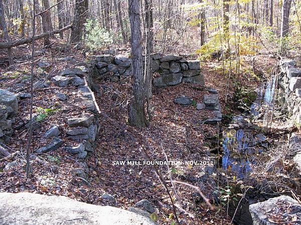
The foundation looking from the waterfalls. |

site from the man-made pond. |

and the fire road on its way to the mill site. |

The pond which was created by damming the stream flowing from it. Since the stream is no longer dammed it has become a swampy wetland.
People lived along Tower Road in those days before electricity and central heating. They must have endured cold winters and dark nights. The danger from wild animals and obstacles mainly at night must have been extreme. These are the foundations of some of those homesteads. |

.Some old bottles and nails found on the site of one of the foundations. They may not look like much or what we’d (and probably they would have) call trash. This, however, should be left at the site and undisturbed as much as possible. They are things these people, who lived over 100 years ago, used in their everyday lives giving future generations a clue to how they lived. To Sum Up The same situation seems to exist today as in 1905. The Town Forest could become something of a tourist attraction and an addition to Mendon's recreation locations. It's possible that the Conservation Commission could once again gain revenue from an observation tower and more (hiking & bicycle trails, picnic areas, preservation of the archeological sites, the forest and stone walls for education and historical research) although the costs might be prohibitive in this budget tightening economy. Tower Road would need improving from Millville Road in Mendon to near the Millville town line, the cost to provide and maintain the site for recreational purposes and for a monitor(s) who would be needed to oversee the site. If, however, these things were to happen, such a place might be an additional incentive for a Bed and Breakfast to locate in the town. True, it was tried once before and failed, but developing the Town Forest for a recreation and historical site, together with the many other wonderful attractions in the area; Southwick’s Zoo, the Blackstone Canal, Purgatory Chasm, the nostalgia of the Mendon Drive-in and George’s Surf & Turf car hop, the many fine restaurants in town as well as the many other attractions from surrounding communities. The proprietor of such an establishment could advertise this to attract customers. Maybe it is time for Mendon to rediscover this long lost recreational treasure, not only for the pleasure of our own residents, but as a possible tourist attraction. The Town of Mendon was once a popular destination for tourists from nearby cities. When surrounding towns suffered the effects of industrial pollution, our local inn keepers advertised Mendon’s spectacular views, clean air, and pure water. In the year 2012, the Town of Mendon still has spectacular views, clean air, and pure water. Mendon’s town forest is a gem which should not go undiscovered.
*************************************** Footnotes & Sources: 1 - John G. Metcalf, M.D, The Annals of Mendon from 1659-1880, E. L. Freeman & Company publisher, Providence, R.I.—1880 2 - Albert E. Jones, “Wigwam Hill”, The Telegram, 1904 or 1905. 3 - Milford Daily Journal, August 14, 1897. Other Sources: Milford Daily Journal, August 20, 1915. Milford Daily Journal, May 13, 1916. Milford Daily News, August 20, 1954. Taft Family Association, “Taft Tree Talks”, June 2004 From the research of Richard Taft Messinger and others. Town Forest Committee Report, January 1, 1945. Rexford V. N. Baker, Yankee Forest Cooperative Project, P. O. Box 760, Chepachet, R.I. 02814. More on the Town Forest Town Forest Report, 1989 Mendon Menu |


Wigwam Hill and the surrounding area in 1870. |

One of the 3 individual carvings. The date, April 28th, 1876 was nearly 2 months before the Battle of Little Big Horn (June 25th) known as Custer’s Last Stand. Ulysses S. Grant was President of 37 U. S. states |

 |  |  |